
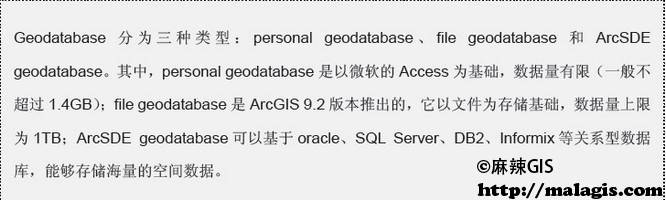
全国高分辨率土地利用数据服务 土地利用数据服务 土地覆盖数据服务 坡度数据服务 土壤侵蚀数据服务 全国各省市DEM数据服务 耕地资源空间分布数据服务 草地资源空间分布数据服务 林地资源空间分布数据服务 水域资源空间分布数据服务 建设用地空间分布数据服务 地形、地貌、土壤数据服务 分坡度耕地数据服务 全国大宗农作物种植范围空间分布数据服务
多种卫星遥感数据反演植被覆盖度数据服务 地表反照率数据服务 比辐射率数据服务 地表温度数据服务 地表蒸腾与蒸散数据服务 归一化植被指数数据服务 叶面积指数数据服务 净初级生产力数据服务 净生态系统生产力数据服务 生态系统总初级生产力数据服务 生态系统类型分布数据服务 土壤类型质地养分数据服务 生态系统空间分布数据服务 增强型植被指数数据服务
多年平均气温空间分布数据服务 多年平均降水量空间分布数据服务 湿润指数数据服务 大于0℃积温空间分布数据服务 光合有效辐射分量数据服务 显热/潜热信息数据服务 波文比信息数据服务 地表净辐射通量数据服务 光合有效辐射数据服务 温度带分区数据服务 山区小气候因子精细数据服务
全国夜间灯光指数数据服务 全国GDP公里格网数据服务 全国建筑物总面积公里格网数据服务 全国人口密度数据服务 全国县级医院分布数据服务 人口调查空间分布数据服务 收入统计空间分布数据服务 矿山面积统计及分布数据服务 载畜量及空间分布数据服务 农作物种植面积统计数据服务 农田分类面积统计数据服务 农作物长势遥感监测数据服务 医疗资源统计数据服务 教育资源统计数据服务 行政辖区信息数据服务
Landsat 8 高分二号 高分一号 SPOT-6卫星影像 法国Pleiades高分卫星 资源三号卫星 风云3号 中巴资源卫星 NOAA/AVHRR MODIS Landsat TM 环境小卫星 Landsat MSS 天绘一号卫星影像


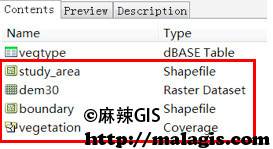
现在,越来越多的组织和个人选择使用 Geodatabase 格式来组织其空间数据。下面我们将学习如何将已有的数据导入 Geodatabase 空间数据空中。 示例数据在…\DATA\BuildingGeodatabase 中,该文件夹中的内容是某保护区的地形及植被信息,还有该保护区的范围以及研究区域范围。我们的练习目的是要在该文件夹中创建一个 Geodatabase, 将所有数据转换为 Geodatabase 格式。
创建空间数据
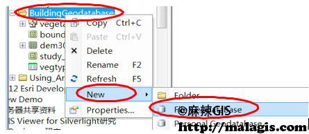
(1) 在 ArcCatalog 中定位到…\DATA\BuildingGeodatabase,右键单 击 BuildingGeodatabase —> New —> File Geodatabase,创建 Geodatabase。
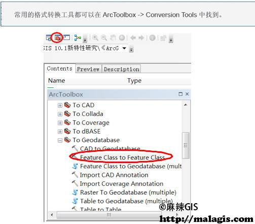
(2) 点击工具栏上的红色工具箱,打开 ArcToolbox。定位到 ArcToolbox
—> Conversion Tools —> To Geodatabase —> Feature Class to Feature Class 工具,双击打开此工具。
(3) 在弹出的 feature class to feature class 工具窗口中, Input Features 项 填 入…\DATA\BuildingGeodatabase\vegetation\polygon;Output Location 项填入 …\DATA\BuildingGeodatabase\New File Geodatabase.gdb;Output Feature Class 项填入 vegetation。点 击 OK,即可开始入库格式转换。工具运行是在后台进行,转换完成 后,会在显示器右下角弹出处理结果。
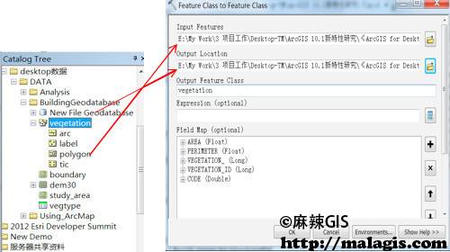
上述操作是将 coverage 格式的 vegetation 中的 polygon 转换为 Geodatabase 格式的数据,存储在第一步新建的 Geodatabase 中,转换后的 新要素类名称为 vegetation。使用该工具不仅能够转换 coverage 格式的数据,还能够将 shapefile 或者 CAD 的数据转换为 Geodatabase 格式。
(4) 使用上述相同的方法(Feature Class to Feature Class 工具), 将 …\DATA\BuildingGeodatabase\boundary.shp 和 study_area.shp 分别转化为 Geodatabase 格式,导入 New File Geodatabase.gdb 中。
栅格数据入库
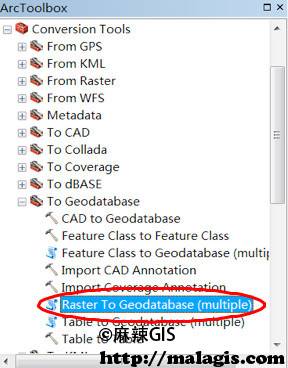
(1) 定位到 ArcToolbox —> Conversion Tools —> To Geodatabase—> Raster To Geodatabase(multiple)工具,双击将其打开。
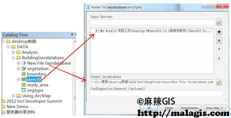
(2) Input Rasters 项填入…\DATA\BuildingGeodatabase\dem30; Output Geodatabase 项 填 入…\data\BuildingGeodatabase\New File Geodatabase.gdb, 点击 OK 即可将栅格数据 dem30 导入到 Geodatabase 中。
(3) 若还有更多栅格数据,需要拼接为一幅图存储,则可在已导入栅格的基础上进行数据追加。对第 2 步已导入 Geodatabase 的 dem30 右键 —> Load —>Load Data,即可开始栅格图幅的拼接工作。


