全国高分辨率土地利用数据服务 土地利用数据服务 土地覆盖数据服务 坡度数据服务 土壤侵蚀数据服务 全国各省市DEM数据服务 耕地资源空间分布数据服务 草地资源空间分布数据服务 林地资源空间分布数据服务 水域资源空间分布数据服务 建设用地空间分布数据服务 地形、地貌、土壤数据服务 分坡度耕地数据服务 全国大宗农作物种植范围空间分布数据服务
多种卫星遥感数据反演植被覆盖度数据服务 地表反照率数据服务 比辐射率数据服务 地表温度数据服务 地表蒸腾与蒸散数据服务 归一化植被指数数据服务 叶面积指数数据服务 净初级生产力数据服务 净生态系统生产力数据服务 生态系统总初级生产力数据服务 生态系统类型分布数据服务 土壤类型质地养分数据服务 生态系统空间分布数据服务 增强型植被指数数据服务
多年平均气温空间分布数据服务 多年平均降水量空间分布数据服务 湿润指数数据服务 大于0℃积温空间分布数据服务 光合有效辐射分量数据服务 显热/潜热信息数据服务 波文比信息数据服务 地表净辐射通量数据服务 光合有效辐射数据服务 温度带分区数据服务 山区小气候因子精细数据服务
全国夜间灯光指数数据服务 全国GDP公里格网数据服务 全国建筑物总面积公里格网数据服务 全国人口密度数据服务 全国县级医院分布数据服务 人口调查空间分布数据服务 收入统计空间分布数据服务 矿山面积统计及分布数据服务 载畜量及空间分布数据服务 农作物种植面积统计数据服务 农田分类面积统计数据服务 农作物长势遥感监测数据服务 医疗资源统计数据服务 教育资源统计数据服务 行政辖区信息数据服务
Landsat 8 高分二号 高分一号 SPOT-6卫星影像 法国Pleiades高分卫星 资源三号卫星 风云3号 中巴资源卫星 NOAA/AVHRR MODIS Landsat TM 环境小卫星 Landsat MSS 天绘一号卫星影像


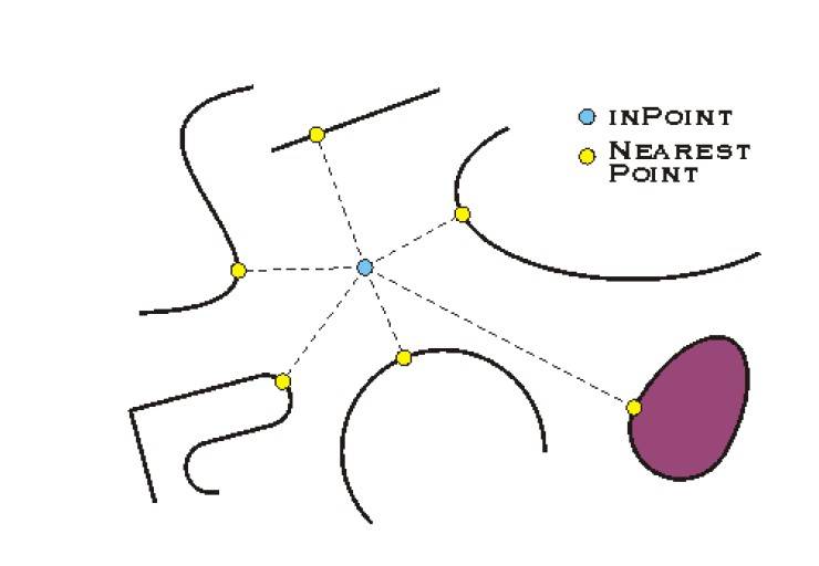
临近操作用于确定一个到多个要素、或两个要素类间的要素邻近性。它经常用来识别和一个要素最近 的其他要素或 者两个要素间 的最短距离等 ,在 ArcGIS Engine 中, 实现临近分析 操作的接口是 IProximityOperator,IProximityOperator 接口只有三个方法,如下:
这三个方法主要用于得到两个几何对象之间的距离或得到一个给定点到某个几个对象的最近点之间的距离,比如我们求一个点到一个多边形的最近的点,就可以用这个接口。下图展示了一个查找最近点的示例:
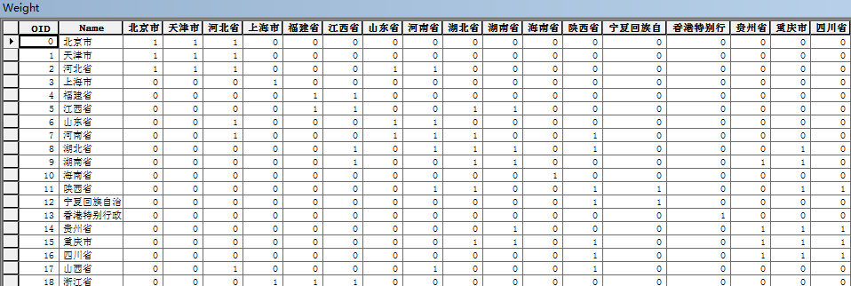
示例:通过临近分析操作实现Moran'I中的邻接矩阵
Moran'I 分为全局和局部两种。
通常情况,先做一个地区的全局 I 指数,全局指数只是告诉我们空间是否出现了集聚或异常值, 但并没有告诉我们在哪里出现。换句话说全局 Moran'I 只回答 Yes 还是 NO;如果全局有自相关出现,接着 做局部自相关;局部 Moran'I 会告诉我们哪里出现了异常值或者哪里出现了集聚,是一个回答 Where 的工具。在 计算 Moran 的时候有一个很关键的步骤就是计算邻接矩阵,借助 IProximityOperator 接口我们可以生成这 样一个矩阵表,代码如下:
/// <summary>
/// 这个字段要是唯一的
/// </summary>
/// <param name="_FilePath"></param>
/// <param name="_TableName"></param>
/// <param name="_pFeatureClass"></param>
/// <param name="_FieldName"></param>
/// <returns></returns>
private ITable CreateWeightTable (string _FilePath, string _TableName, IFeatureClass _pFeatureClass, string _FieldName)
{
IWorkspaceFactory pWks = new ShapefileWorkspaceFactoryClass ();
IFeatureWorkspace pFwk = pWks.OpenFromFile (_FilePath, 0) as IFeatureWorkspace;
//用于添加表中的必要字段
ESRI.ArcGIS.Geodatabase.IObjectClassDescription objectClassDescription = new ESRI.ArcGIS.Geodatabase.ObjectClassDescriptionClass ();
IFields pTableFields = objectClassDescription.RequiredFields;
IFieldsEdit pTableFieldsEdit = pTableFields as IFieldsEdit;
int index = _pFeatureClass.FindField (_FieldName);
IField pField = new FieldClass ();
IFieldEdit pFieldEdit = pField as IFieldEdit;
pFieldEdit.Name_2 = _FieldName;
pTableFieldsEdit.AddField (pFieldEdit);
pFieldEdit.Type_2 = _pFeatureClass.Fields.get_Field (index).Type;
IFeatureCursor pFtCursor = _pFeatureClass.Search (null, false);
IFeature pFt = pFtCursor.NextFeature ();
while (pFt != null)
{
IField pFieldv = new FieldClass ();
IFieldEdit pFieldEditv = pFieldv as IFieldEdit;
pFieldEditv.Name_2 = pFt.get_Value (index).ToString ();
pFieldEditv.Type_2 = esriFieldType.esriFieldTypeInteger;
pTableFieldsEdit.AddField (pFieldEditv);
pFt = pFtCursor.NextFeature ();
}
ITable pTable = pFwk.CreateTable (_TableName, pTableFields, null, null, "");
IFeatureCursor pFtCursor1 = _pFeatureClass.Search (null, false);
IFeature pFt1 = pFtCursor1.NextFeature ();
while (pFt1 != null)
{
IRow pRow = pTable.CreateRow ();
pRow.set_Value (1, pFt1.get_Value (index));
pRow.Store ();
pFt1 = pFtCursor1.NextFeature ();
}
return pTable;
}
IFeatureClass pPolygonFClass = GetFeatureClass (@"D:\空间查询\分析用的空间数据", "行政区");
ITable pTable = CreateWeightTable (@"D:\空间查询\分析用的空间数据", "Weight", pPolygonFClass, "NAME");
IFeature pFt1, pFt2;
IFeatureCursor pFtCur1, pFtCur2;
pFtCur1 = pPolygonFClass.Search (null, false);
pFt1 = pFtCur1.NextFeature ();
ICursor pCursor = pTable.Update (null, false);
IRow pRow = pCursor.NextRow ();
int j = 0;
///这里是关键,在这里进行计算,这里可以通过计算上三角或者下三角进行优化
while (pFt1 != null)
{
IProximityOperator pProx = pFt1.Shape as IProximityOperator;
pFtCur2 = pPolygonFClass.Search (null, false);
pFt2 = pFtCur2.NextFeature ();
while (pFt2 != null)
{
double dis = pProx.ReturnDistance (pFt2.Shape);
if (dis == 0)
{
pRow.set_Value (j + 2, 1);
pRow.Store ();
}
}
j = 0;
pFt2 = pFtCur2.NextFeature ();
j++;
pRow = pCursor.NextRow ();
pFt1 = pFtCur1.NextFeature ();
}